 Edit article
Series
Israel’s Earthquake, 8th Century B.C.E.

Tel Agol
The Bible twice mentions an earthquake that occurred during the reign of King Uzziah of Judah (8th cent. B.C.E.). The Book of Amos uses the earthquake to establish the year in which Amos began to prophesize:
עמוס א:א דִּבְרֵי עָמוֹס אֲשֶׁר הָיָה בַנֹּקְדִים מִתְּקוֹעַ אֲשֶׁר חָזָה עַל יִשְׂרָאֵל בִּימֵי עֻזִּיָּה מֶלֶךְ יְהוּדָה וּבִימֵי יָרָבְעָם בֶּן יוֹאָשׁ מֶלֶךְ יִשְׂרָאֵל שְׁנָתַיִם לִפְנֵי הָרָעַשׁ.
Amos 1:1 The words of Amos, a sheepbreeder from Tekoa, who prophesied concerning Israel in the reigns of Kings Uzziah of Judah and Jeroboam son of Joash of Israel, two years before the earthquake.
Deutero-Zechariah[1] compares the damage caused by the earthquake to the anticipated effect on the land in the future, when YHWH will set foot on the Mount of Olives to make war on the nations of the world.
זכריה יד:ה וְנַסְתֶּם גֵּיא הָרַי כִּי יַגִּיעַ גֵּי הָרִים אֶל אָצַל וְנַסְתֶּם כַּאֲשֶׁר נַסְתֶּם מִפְּנֵי הָרַעַשׁ בִּימֵי עֻזִּיָּה מֶלֶךְ יְהוּדָה וּבָא יְ־הוָה אֱלֹהַי כָּל קְדֹשִׁים עִמָּךְ.
Zech 14:5 And the Valley in the Hills shall be stopped up, for the Valley of the Hills shall reach only to Azal; it shall be stopped up as it was stopped up as a result of the earthquake in the days of King Uzziah of Judah. And YHWH my God, with all the holy beings, will come to you.
Archaeological evidence unearthed at Tel Agol, in the Jezreel Valley, confirms this earthquake, and showcases its devastating impact on the settlement, highlighting why the earthquake made such an impression on biblical authors.
Tel Agol
About 9 miles northeast of modern-day Afula, the Iron Age hilltop settlement at Tel Agol, just 40 or so yards south of the hill’s summit, is over 1,000 feet above sea level, and about 3 miles south-west of Mount Tabor.[2] It owes its importance in the early 1st millennium B.C.E. to its strategic location, controlling a huge section of the Jezreel Valley, as well as to its fertile soils (in the Ksolot Rift).[3] A 2014 salvage excavation[4] of the Israel Antiquities Authority found three stages of fortification dating from the Iron II site (10th to the 8th centuries B.C.E.) and uncovered the impact of the earthquake on the settlement.[5]
Phase 1: A Massive Stone Wall
The earliest stage of the site’s fortification was a massive stone wall. Archaeologists uncovered a few segments of single layer of stone along a 55-foot stretch.[6] At its western end, it formed the base for a superstructure, encompassing part of a podium or a high platform. Despite the limited exposure of this massive wall, we may assume it was used as part of a fortification wall or a tower towards the south.
Such fortification was likely useful in Israel’s constant wars with its neighbors, such as the Aramean polities to their north. Nevertheless, its construction here fits with a broader pattern of Israel fortifying itself against Assyrian incursions.
Towards the end of the 10th century B.C.E., King Adad-Nirari II (911–891 B.C.E.) established the Neo-Assyrian Empire, and he and his successors began raiding and eventually conquering the Levant. Especially notable in this period was King Shalmaneser III (859–824 B.C.E.). While he is not mentioned anywhere in the Bible, Akkadian sources note at least two of his incursions against Israel.
The Kurkh Monolith, a royal inscription in Akkadian, describes the battle of Qarqar (853 B.C.E.), which King Shalmaneser III of Assyria fought against a league of Levantine armies. Ahab of Israel is listed third, after Damascus and Hamath, as having brought 2,000 chariots, 10,000 soldiers.[7]
Another royal inscription from 841 B.C.E, known as the Black Obelisk describes how King Jehu of Israel paid Shalmaneser III tribute.[8] Jehu’s obeisance is graphically depicted there. Another version of this text appears on a marble slab in Ashur, in which Shalmaneser III states explicitly that he marched across Israel:
I marched as far as the mountain(s) of Hauran. Cities without number, I destroyed, tore down, and burned, and carried off their spoil. I marched to Mount Baʿali-rasi, at the head of the sea facing Tyre, and set up my royal stela there. I received tribute of Baʿali-manzari of Tyre (and) Jehu, son of Omri.[9]
The Hauran refers to Jebel ed-Druz, in the modern-day Golan Heights and southern Syria. Thus, the “cities without number” were Israelite cities. Moreover, when he marched to the coastal Mount Baʿali-rasi (modern day Rosh Hanikra) from the Hauran, he would have used the Jezreel Valley as his highway, and thus would have literally passed by Tel Agol with this army. The text makes no mention of his conquering sites in this region, which is best explained by Jehu’s having submitted to Shalmaneser and paid him tribute. These campaigns illustrate the international political problems Israel faced in this period.
Phase 2: The 9th Century Casemate Wall
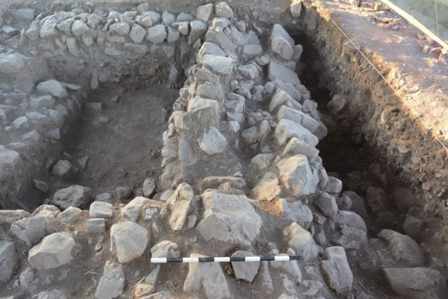
In the 9th century, the space around the massive wall was filled with huge basalt stones to create a new level for a casemate wall, some of which were also built with large basalt stones (not pictured in the photograph below).[10]
Casemate walls consist of two parallel walls, between which perpendicular walls are built that divide the open space into differently sized rooms, called casemates, which can be used for any purpose: a place for guards, storage rooms, etc. Thus, they are more efficient than thick walls, as they allow for double use. Among the five casemates found in the 70-foot of wall exposed at Tel Agol, one was identified as a storeroom and another as a masonry workshop.[11]
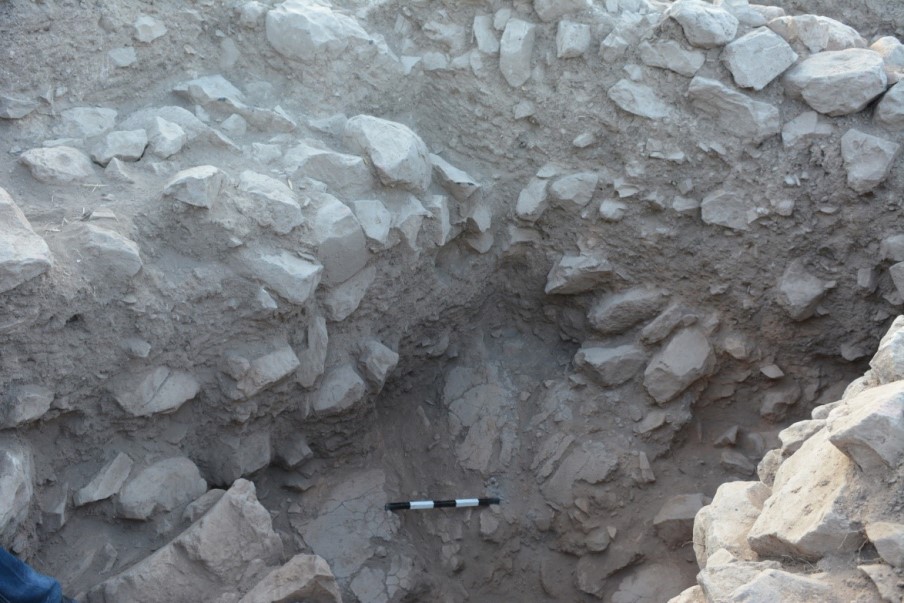
 Storeroom Casemate
Earthquake Damage to the Casemate Wall
At some point after it was constructed, the casemate wall was damaged. We see evidence of this damage in three places:
1. Along the exterior southern wall of the western group of casemates, the upper rows of stones collapsed towards the south. Only the very bottom part of the wall remains, but we were able to see stones scattered all over the area, showing that it was unlivable. These cannot be seen in the pictures, which were taken after the area was cleaned of debris, so that we could get a better look at the structure.[12]

2. At the storeroom-casemate at the north-eastern corner, a few large stones that had fallen from the north wall probably destroyed a clay shelf. This room could have been used for the local food supply or as a part of an administrative center collecting grains or any other crops from the valleys’ sites in the vicinity. Several bowls lying on the clay-shelf remained in their original position. On its floor, researchers also found dozens of crushed pottery vessels, including jars and pithoi—probably containers for food products, such as wheat or other grains—as well as cooking pots.

3. At the eastern casemate, researchers discovered a few fallen stones from the eastern wall.[13]

We concluded that the best explanation for this damage is that an earthquake struck the settlement. Subsequent research carried out by Prof. Shmuel Marco, a geologist who researches earthquakes in historical periods, as well as other geologists from Tel Aviv University, supports this contention.
Phase 3: Repairs to the Wall in the Last Decades of the Settlement
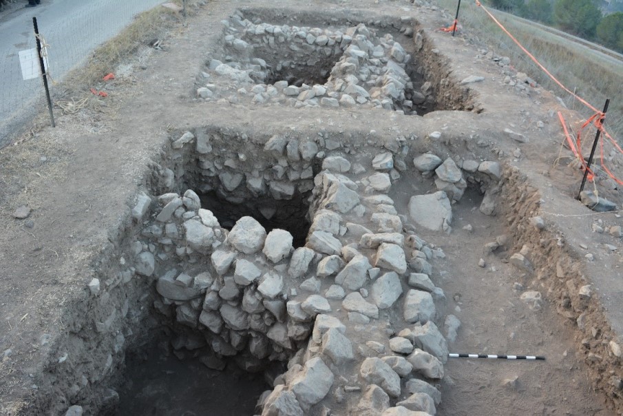
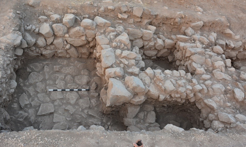
After the earthquake, the inhabitants apparently repaired the casemate wall. This work constitutes the third and final stage of construction. Though parts of the outer wall and partition walls had collapsed, the main structure remained more or less intact, and they stabilized it by adding several rows of stone above the original walls of the fortification.
Rebuilt upper courses in eastern casemate
In the eastern part of the fortification, an entirely new wall was built over the earlier wall, and this arrangement created a new, smaller open space within the wall.
 New walls above the casemate create small rooms/spaces
This rebuilding of the some of the walls allowed part of the site to be reinhabited, although the site was never fully rebuilt.
That the storeroom-casemate still held the broken shelf and pottery vessels that were crushed during the earthquake may suggest that the room went out of use after the earthquake. If so, for whatever reason, the inhabitants felt that rebuilding the storeroom was not worthwhile.
The Period of the Earthquake in Bible and Archaeology
The earthquake that destroyed Tel Agol is almost certainly the same one mentioned in the biblical text. If so, we can use the information from the Bible and the archaeological finds at Tel Agol to date this earthquake to the first half of the 8th century:
- Amos and Zechariah (both quoted above) place the earthquake during the mid-8th century reign of Uzziah of Judah.[14]
- Amos also refers to the reign of Jeroboam II of Israel (ca. 785–745 B.C.E.).
- The pottery found in the casemates consists of locally produced items familiar from mid-8th[15]
Finally, we know that the earthquake must have taken place in the mid-8th century since repairs were made after the earthquake and by the late 8th century, the site was abandoned, in wake of the 732 B.C.E. conquest of the Galilee by Tiglath Pileser III (745–727 B.C.E.) as described in the book of Kings:
מלכים ב טו:כט בִּימֵי פֶּקַח מֶלֶךְ יִשְׂרָאֵל בָּא תִּגְלַת פִּלְאֶסֶר מֶלֶךְ אַשּׁוּר וַיִּקַּח אֶת עִיּוֹן וְאֶת אָבֵל בֵּית מַעֲכָה וְאֶת יָנוֹחַ וְאֶת קֶדֶשׁ וְאֶת חָצוֹר וְאֶת הַגִּלְעָד וְאֶת הַגָּלִילָה כֹּל אֶרֶץ נַפְתָּלִי וַיַּגְלֵם אַשּׁוּרָה.
2 Kgs 15:29 In the days of King Pekah of Israel, King Tiglath-pileser of Assyria came and captured Ijon, Abel-beth-maacah, Janoah, Kedesh, Hazor—Gilead, Galilee, the entire region of Naphtali; and he deported the inhabitants to Assyria.
There are no signs of destruction at the Tel Agol site, but the abandonment of the settlement most likely occurred during this period. Whether they were deported along with the other northern Israelites or whether they escaped south to the Samarian highlands is unknown.
The Date of the Earthquake
Yigael Yadin dated the earthquake to around 760 B.C.E., based on his dating of the stratum that reflects earthquake damage.[16] Others have pushed the date down a bit to around 750 B.C.E.[17] Both dates work with our findings.
In contrast with earthquakes from the early Roman period and onwards, which are mentioned in historical documents, the biblical reference to the earthquake is the only record in ancient sources of an earthquake which can be clearly supported by archaeological remains, both in Tel Agol and other Israelite sites.[18]
Uncovering the Earthquake’s Destructive Power
The failed attempt to rebuild the site demonstrates the long-term destructive power that such an event could have on an ancient city. The weakening of the site by the earthquake may have contributed to its demise shortly thereafter. Whatever the case, at Tel Agol, we are confronted with a bleak picture, namely a settlement’s inability to recover from the earthquake.[19]
TheTorah.com is a 501(c)(3) nonprofit organization.
We rely on the support of readers like you. Please support us.
Published
June 24, 2021
|
Last Updated
December 26, 2025
Previous in the Series
Next in the Series
Before you continue...
Thank you to all our readers who offered their year-end support.
Please help TheTorah.com get off to a strong start in 2025.
Footnotes

Nurit Feig is a senior archaeologist, researcher, and excavator at the Israel Antiquities Authority (IAA), where she has worked since 1980. Previously she was the director of their archive, and led its digitalization project. Feig holds an M.A. in archaeology from Tel Aviv University, where she is also a Ph.D. candidate. She has directed more than 50 salvage excavations, among them the Third Wall and Khirbet er-Ras (Rephaim Valley) at Jerusalem, as well as Tel Afula, Akko and Tel Agol in the North. Among Feig’s articles are “New Discoveries in the Rephaim Valley, Jerusalem” (PEQ 1996); “The Environs of Jerusalem in the Iron Age II (2000); “Excavations at Beith Safafa” (Atiqot 2004), and “Tel ‘Amal – An Iron Age II Settlement in the Beth-Shean Valley” (2013).
Essays on Related Topics:


